field recordings redux
As we start to think about a third series, here are a selection of field recordings from the previous two Continue reading

As we start to think about a third series, here are a selection of field recordings from the previous two Continue reading
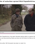
This is possibly Nick’s finest hour (even with the hat on). A great Newsnight feature about Deep Topography and psychogeography Continue reading

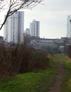
In this final episode of the series, we take you on a lop-sided perambulation through ‘remote London’ from the north-west Continue reading

Download the podcast here
There are various ways you gain an impression of a place and develop a curiosity about it, which eventually inspires Continue reading

One summer’s morning back in 1971, my Dad, my brother Stavros and I set out by taxi from our home Continue reading
Download the podcast of this episode here